
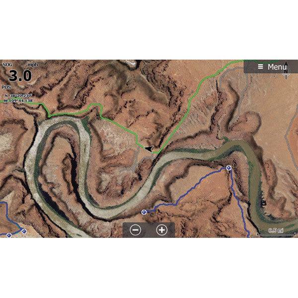
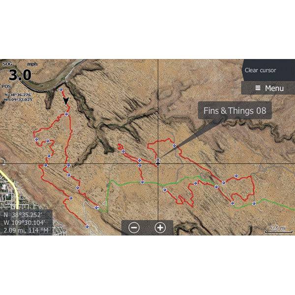

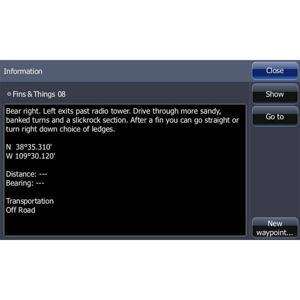
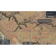
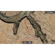
This SD card includes high-definition aerial imagery of trails for use in your Lowrance HDS or Elite GPS system.
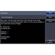
Maps include Trailhead information, waypoint details and trail traces for 55 different trails, including Strike Ravine, Fins and Things, and many more!
Trail List:
|
|
Instructions
- Insert the card and if asked "Do you wish to change chart data selection to view inserted charts" Select yes.
- To change your GPS settings to show the satellite imagery on the HDS Live, Press Menu, Select More Options, Select Chart Options, Select Chart Detail, select Full. Select Photo Overlay and Select Full.
- When you change the map to be the satellite imagery - it is only reading that map. Your normal background mapping is not visible, only the area with the satellite imagery. To switch in between the two on the HDS Live, Press Menu, Select More Options, Select Chart Source. "C-MAP US..." is the factory map, "Lowrance" is usually the satellite imagery map.
Click here for downloadable instructions
{"id":1319250690126,"title":"Moab Lowrance Map","handle":"moab-lowrance-map","description":"\u003cp\u003eThis SD card includes high-definition aerial imagery of trails for use in your Lowrance HDS or Elite GPS system. \u003cbr\u003e\u003c\/p\u003e\n\u003cp\u003e\u003cspan\u003eMaps include Trailhead information, waypoint details and trail traces for 55 different trails, including Strike Ravine, Fins and Things, and many more! \u003c\/span\u003e\u003c\/p\u003e\n\u003cp\u003e\u003cspan mce-data-marked=\"1\"\u003eTrail List:\u003c\/span\u003e\u003c\/p\u003e\n\u003ctable\u003e\n\u003ctbody\u003e\n\u003ctr\u003e\n\u003ctd\u003e\n\u003cul\u003e\n\u003cli\u003eBook Cliffs Sego Canyon\u003c\/li\u003e\n\u003cli\u003eWhite Wash Sand Dunes\u003c\/li\u003e\n\u003cli\u003eTower Arch\u003c\/li\u003e\n\u003cli\u003eTusher Tunnel\u003c\/li\u003e\n\u003cli\u003eHidden Canyon Overlook\u003c\/li\u003e\n\u003cli\u003eHidden Canyon\u003c\/li\u003e\n\u003cli\u003eBartlett Overlook\u003c\/li\u003e\n\u003cli\u003eBartlett Wash Road\u003c\/li\u003e\n\u003cli\u003eSevenmile Rim\u003c\/li\u003e\n\u003cli\u003eRainbow Terrace\u003c\/li\u003e\n\u003cli\u003eSecret Spire Dellenbaugh Tunnel\u003c\/li\u003e\n\u003cli\u003eSpring Canyon Point\u003c\/li\u003e\n\u003cli\u003eSpring Canyon Bottom\u003c\/li\u003e\n\u003cli\u003eHey Joe Canyon\u003c\/li\u003e\n\u003cli\u003eMineral Point\u003c\/li\u003e\n\u003cli\u003eGemini Bridges\u003c\/li\u003e\n\u003cli\u003eMetal Masher\u003c\/li\u003e\n\u003cli\u003eLong Canyon\u003c\/li\u003e\n\u003cli\u003eBull Canyon\u003c\/li\u003e\n\u003cli\u003eGold Bar Rim\u003c\/li\u003e\n\u003cli\u003ePoison Spider Mesa\u003c\/li\u003e\n\u003cli\u003eGolden Spike\u003c\/li\u003e\n\u003cli\u003eCliff Hanger\u003c\/li\u003e\n\u003cli\u003eHurrah Pass\u003c\/li\u003e\n\u003cli\u003eMoab Rim\u003c\/li\u003e\n\u003cli\u003ePritchett Canyon\u003c\/li\u003e\n\u003cli\u003eKane Creek Canyon\u003c\/li\u003e\n\u003c\/ul\u003e\n\u003c\/td\u003e\n\u003ctd\u003e\n\u003cul\u003e\n\u003cli\u003eBehind the Rocks\u003c\/li\u003e\n\u003cli\u003eStrike Ravine\u003c\/li\u003e\n\u003cli\u003ePicture Frame Arch\u003c\/li\u003e\n\u003cli\u003eFlat Iron Mesa\u003c\/li\u003e\n\u003cli\u003eHells Revenge\u003c\/li\u003e\n\u003cli\u003eFins and Things\u003c\/li\u003e\n\u003cli\u003eSand Flats Road\u003c\/li\u003e\n\u003cli\u003eSteel Bender\u003c\/li\u003e\n\u003cli\u003eOnion Creek Fisher Towers\u003c\/li\u003e\n\u003cli\u003eDome Plateau\u003c\/li\u003e\n\u003cli\u003eTop of the World\u003c\/li\u003e\n\u003cli\u003eDolores River Overlook\u003c\/li\u003e\n\u003cli\u003eRose Garden Hill\u003c\/li\u003e\n\u003cli\u003eThompson Canyon Polar Mesa\u003c\/li\u003e\n\u003cli\u003eCastle Gateway Road\u003c\/li\u003e\n\u003cli\u003eGeyser Pass\u003c\/li\u003e\n\u003cli\u003eLa Sal Pass\u003c\/li\u003e\n\u003cli\u003ePotash Road Shafer Switchbacks\u003c\/li\u003e\n\u003cli\u003eWhite Rim\u003c\/li\u003e\n\u003cli\u003eLathrop Canyon\u003c\/li\u003e\n\u003cli\u003eChicken Corners\u003c\/li\u003e\n\u003cli\u003eLockhart Basin\u003c\/li\u003e\n\u003cli\u003eLockhart Canyon\u003c\/li\u003e\n\u003cli\u003eCanyon Rim Overlooks\u003c\/li\u003e\n\u003cli\u003eColorado River Overlook\u003c\/li\u003e\n\u003cli\u003eElephant Hill\u003c\/li\u003e\n\u003cli\u003eLavender Canyon\u003c\/li\u003e\n\u003cli\u003eBeef Basin\u003c\/li\u003e\n\u003c\/ul\u003e\n\u003c\/td\u003e\n\u003c\/tr\u003e\n\u003c\/tbody\u003e\n\u003c\/table\u003e\n\u003cp\u003e \u003c\/p\u003e\n\u003ch5\u003eInstructions \u003c\/h5\u003e\n\u003cul\u003e\n\u003cli\u003eInsert the card and if asked \"Do you wish to change chart data selection to view inserted charts\" Select yes.\u003c\/li\u003e\n\u003cli\u003eTo change your GPS settings to show the satellite imagery on the HDS Live, Press Menu, Select More Options, Select Chart Options, Select Chart Detail, select Full. Select Photo Overlay and Select Full.\u003c\/li\u003e\n\u003cli\u003eWhen you change the map to be the satellite imagery - it is only reading that map. Your normal background mapping is not visible, only the area with the satellite imagery. To switch in between the two on the HDS Live, Press Menu, Select More Options, Select Chart Source. \"C-MAP US...\" is the factory map, \"Lowrance\" is usually the satellite imagery map. \u003c\/li\u003e\n\u003c\/ul\u003e\n\u003cp\u003e\u003ca href=\"https:\/\/cdn.shopify.com\/s\/files\/1\/0769\/1859\/files\/PCI_Rugged_Routes_Sat_Imagery_GPS_Instructions_b01a5fc3-71b8-43a0-b118-7234f940d02b.pdf?v=1646167340\" data-mce-href=\"https:\/\/cdn.shopify.com\/s\/files\/1\/0769\/1859\/files\/PCI_Rugged_Routes_Sat_Imagery_GPS_Instructions_b01a5fc3-71b8-43a0-b118-7234f940d02b.pdf?v=1646167340\" target=\"_blank\"\u003eClick here for downloadable instructions\u003c\/a\u003e\u003c\/p\u003e\n\u003cul\u003e\u003c\/ul\u003e\n\u003cstyle\u003e\u003c\/style\u003e\n\u003cstyle\u003e\u003c\/style\u003e","published_at":"2018-04-04T15:53:48-07:00","created_at":"2018-04-04T15:55:25-07:00","vendor":"PCI Race Radios","type":"","tags":[],"price":11999,"price_min":11999,"price_max":11999,"available":true,"price_varies":false,"compare_at_price":null,"compare_at_price_min":0,"compare_at_price_max":0,"compare_at_price_varies":false,"variants":[{"id":12200561999950,"title":"Default Title","option1":"Default Title","option2":null,"option3":null,"sku":"3268","requires_shipping":true,"taxable":true,"featured_image":null,"available":true,"name":"Moab Lowrance Map","public_title":null,"options":["Default Title"],"price":11999,"weight":907,"compare_at_price":null,"inventory_quantity":-63,"inventory_management":null,"inventory_policy":"deny","barcode":"003268","requires_selling_plan":false,"selling_plan_allocations":[],"quantity_rule":{"min":1,"max":null,"increment":1}}],"images":["\/\/www.pciraceradios.com\/cdn\/shop\/files\/pci-race-radios-default-title-moab-lowrance-map-3608181571662.jpg?v=1736203844","\/\/www.pciraceradios.com\/cdn\/shop\/files\/pci-race-radios-default-title-moab-lowrance-map-3608181801038.jpg?v=1736203846","\/\/www.pciraceradios.com\/cdn\/shop\/files\/pci-race-radios-default-title-moab-lowrance-map-3608181866574.jpg?v=1736203841","\/\/www.pciraceradios.com\/cdn\/shop\/files\/pci-race-radios-default-title-moab-lowrance-map-3608181899342.jpg?v=1736203838"],"featured_image":"\/\/www.pciraceradios.com\/cdn\/shop\/files\/pci-race-radios-default-title-moab-lowrance-map-3608181571662.jpg?v=1736203844","options":["Title"],"media":[{"alt":"Moab Lowrance Map - PCI Race Radios","id":35163734278385,"position":1,"preview_image":{"aspect_ratio":1.0,"height":600,"width":600,"src":"\/\/www.pciraceradios.com\/cdn\/shop\/files\/pci-race-radios-default-title-moab-lowrance-map-3608181571662.jpg?v=1736203844"},"aspect_ratio":1.0,"height":600,"media_type":"image","src":"\/\/www.pciraceradios.com\/cdn\/shop\/files\/pci-race-radios-default-title-moab-lowrance-map-3608181571662.jpg?v=1736203844","width":600},{"alt":"Moab Lowrance Map - PCI Race Radios","id":35163734409457,"position":2,"preview_image":{"aspect_ratio":1.0,"height":600,"width":600,"src":"\/\/www.pciraceradios.com\/cdn\/shop\/files\/pci-race-radios-default-title-moab-lowrance-map-3608181801038.jpg?v=1736203846"},"aspect_ratio":1.0,"height":600,"media_type":"image","src":"\/\/www.pciraceradios.com\/cdn\/shop\/files\/pci-race-radios-default-title-moab-lowrance-map-3608181801038.jpg?v=1736203846","width":600},{"alt":"Moab Lowrance Map - PCI Race Radios","id":35163734147313,"position":3,"preview_image":{"aspect_ratio":1.0,"height":600,"width":600,"src":"\/\/www.pciraceradios.com\/cdn\/shop\/files\/pci-race-radios-default-title-moab-lowrance-map-3608181866574.jpg?v=1736203841"},"aspect_ratio":1.0,"height":600,"media_type":"image","src":"\/\/www.pciraceradios.com\/cdn\/shop\/files\/pci-race-radios-default-title-moab-lowrance-map-3608181866574.jpg?v=1736203841","width":600},{"alt":"Moab Lowrance Map - PCI Race Radios","id":35163733950705,"position":4,"preview_image":{"aspect_ratio":1.0,"height":600,"width":600,"src":"\/\/www.pciraceradios.com\/cdn\/shop\/files\/pci-race-radios-default-title-moab-lowrance-map-3608181899342.jpg?v=1736203838"},"aspect_ratio":1.0,"height":600,"media_type":"image","src":"\/\/www.pciraceradios.com\/cdn\/shop\/files\/pci-race-radios-default-title-moab-lowrance-map-3608181899342.jpg?v=1736203838","width":600}],"requires_selling_plan":false,"selling_plan_groups":[],"content":"\u003cp\u003eThis SD card includes high-definition aerial imagery of trails for use in your Lowrance HDS or Elite GPS system. \u003cbr\u003e\u003c\/p\u003e\n\u003cp\u003e\u003cspan\u003eMaps include Trailhead information, waypoint details and trail traces for 55 different trails, including Strike Ravine, Fins and Things, and many more! \u003c\/span\u003e\u003c\/p\u003e\n\u003cp\u003e\u003cspan mce-data-marked=\"1\"\u003eTrail List:\u003c\/span\u003e\u003c\/p\u003e\n\u003ctable\u003e\n\u003ctbody\u003e\n\u003ctr\u003e\n\u003ctd\u003e\n\u003cul\u003e\n\u003cli\u003eBook Cliffs Sego Canyon\u003c\/li\u003e\n\u003cli\u003eWhite Wash Sand Dunes\u003c\/li\u003e\n\u003cli\u003eTower Arch\u003c\/li\u003e\n\u003cli\u003eTusher Tunnel\u003c\/li\u003e\n\u003cli\u003eHidden Canyon Overlook\u003c\/li\u003e\n\u003cli\u003eHidden Canyon\u003c\/li\u003e\n\u003cli\u003eBartlett Overlook\u003c\/li\u003e\n\u003cli\u003eBartlett Wash Road\u003c\/li\u003e\n\u003cli\u003eSevenmile Rim\u003c\/li\u003e\n\u003cli\u003eRainbow Terrace\u003c\/li\u003e\n\u003cli\u003eSecret Spire Dellenbaugh Tunnel\u003c\/li\u003e\n\u003cli\u003eSpring Canyon Point\u003c\/li\u003e\n\u003cli\u003eSpring Canyon Bottom\u003c\/li\u003e\n\u003cli\u003eHey Joe Canyon\u003c\/li\u003e\n\u003cli\u003eMineral Point\u003c\/li\u003e\n\u003cli\u003eGemini Bridges\u003c\/li\u003e\n\u003cli\u003eMetal Masher\u003c\/li\u003e\n\u003cli\u003eLong Canyon\u003c\/li\u003e\n\u003cli\u003eBull Canyon\u003c\/li\u003e\n\u003cli\u003eGold Bar Rim\u003c\/li\u003e\n\u003cli\u003ePoison Spider Mesa\u003c\/li\u003e\n\u003cli\u003eGolden Spike\u003c\/li\u003e\n\u003cli\u003eCliff Hanger\u003c\/li\u003e\n\u003cli\u003eHurrah Pass\u003c\/li\u003e\n\u003cli\u003eMoab Rim\u003c\/li\u003e\n\u003cli\u003ePritchett Canyon\u003c\/li\u003e\n\u003cli\u003eKane Creek Canyon\u003c\/li\u003e\n\u003c\/ul\u003e\n\u003c\/td\u003e\n\u003ctd\u003e\n\u003cul\u003e\n\u003cli\u003eBehind the Rocks\u003c\/li\u003e\n\u003cli\u003eStrike Ravine\u003c\/li\u003e\n\u003cli\u003ePicture Frame Arch\u003c\/li\u003e\n\u003cli\u003eFlat Iron Mesa\u003c\/li\u003e\n\u003cli\u003eHells Revenge\u003c\/li\u003e\n\u003cli\u003eFins and Things\u003c\/li\u003e\n\u003cli\u003eSand Flats Road\u003c\/li\u003e\n\u003cli\u003eSteel Bender\u003c\/li\u003e\n\u003cli\u003eOnion Creek Fisher Towers\u003c\/li\u003e\n\u003cli\u003eDome Plateau\u003c\/li\u003e\n\u003cli\u003eTop of the World\u003c\/li\u003e\n\u003cli\u003eDolores River Overlook\u003c\/li\u003e\n\u003cli\u003eRose Garden Hill\u003c\/li\u003e\n\u003cli\u003eThompson Canyon Polar Mesa\u003c\/li\u003e\n\u003cli\u003eCastle Gateway Road\u003c\/li\u003e\n\u003cli\u003eGeyser Pass\u003c\/li\u003e\n\u003cli\u003eLa Sal Pass\u003c\/li\u003e\n\u003cli\u003ePotash Road Shafer Switchbacks\u003c\/li\u003e\n\u003cli\u003eWhite Rim\u003c\/li\u003e\n\u003cli\u003eLathrop Canyon\u003c\/li\u003e\n\u003cli\u003eChicken Corners\u003c\/li\u003e\n\u003cli\u003eLockhart Basin\u003c\/li\u003e\n\u003cli\u003eLockhart Canyon\u003c\/li\u003e\n\u003cli\u003eCanyon Rim Overlooks\u003c\/li\u003e\n\u003cli\u003eColorado River Overlook\u003c\/li\u003e\n\u003cli\u003eElephant Hill\u003c\/li\u003e\n\u003cli\u003eLavender Canyon\u003c\/li\u003e\n\u003cli\u003eBeef Basin\u003c\/li\u003e\n\u003c\/ul\u003e\n\u003c\/td\u003e\n\u003c\/tr\u003e\n\u003c\/tbody\u003e\n\u003c\/table\u003e\n\u003cp\u003e \u003c\/p\u003e\n\u003ch5\u003eInstructions \u003c\/h5\u003e\n\u003cul\u003e\n\u003cli\u003eInsert the card and if asked \"Do you wish to change chart data selection to view inserted charts\" Select yes.\u003c\/li\u003e\n\u003cli\u003eTo change your GPS settings to show the satellite imagery on the HDS Live, Press Menu, Select More Options, Select Chart Options, Select Chart Detail, select Full. Select Photo Overlay and Select Full.\u003c\/li\u003e\n\u003cli\u003eWhen you change the map to be the satellite imagery - it is only reading that map. Your normal background mapping is not visible, only the area with the satellite imagery. To switch in between the two on the HDS Live, Press Menu, Select More Options, Select Chart Source. \"C-MAP US...\" is the factory map, \"Lowrance\" is usually the satellite imagery map. \u003c\/li\u003e\n\u003c\/ul\u003e\n\u003cp\u003e\u003ca href=\"https:\/\/cdn.shopify.com\/s\/files\/1\/0769\/1859\/files\/PCI_Rugged_Routes_Sat_Imagery_GPS_Instructions_b01a5fc3-71b8-43a0-b118-7234f940d02b.pdf?v=1646167340\" data-mce-href=\"https:\/\/cdn.shopify.com\/s\/files\/1\/0769\/1859\/files\/PCI_Rugged_Routes_Sat_Imagery_GPS_Instructions_b01a5fc3-71b8-43a0-b118-7234f940d02b.pdf?v=1646167340\" target=\"_blank\"\u003eClick here for downloadable instructions\u003c\/a\u003e\u003c\/p\u003e\n\u003cul\u003e\u003c\/ul\u003e\n\u003cstyle\u003e\u003c\/style\u003e\n\u003cstyle\u003e\u003c\/style\u003e"}