


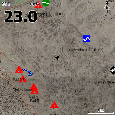
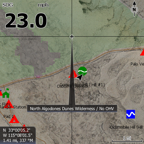
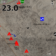
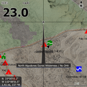
Satellite Imagery for Lowrance GPS units of Glamis Dunes / Imperial Sand Dunes.
Imagery resolution is 1-Meter/Px.
Compatible with Lowrance HDS & Elite GPS units.
Includes:
- Fee Area Boundary
- OHV Boundary
- Competition Hill
- Oldsmobile Hill
- Brawley Slide
- Lizard Hill
- China Wall
- The Ceiling
- Critical Habitat Closures
- Camping Area Closures
- Wilderness Boundaries
- Ranger Stations
- Washes
- Ranger Stations
- Campgrounds
- Restrooms
Instructions
- Insert the card and if asked "Do you wish to change chart data selection to view inserted charts" Select yes.
- To change your GPS settings to show the satellite imagery on the HDS Live, Press Menu, Select More Options, Select Chart Options, Select Chart Detail, select Full. Select Photo Overlay and Select Full.
- When you change the map to be the satellite imagery - it is only reading that map. Your normal background mapping is not visible, only the area with the satellite imagery. To switch in between the two on the HDS Live, Press Menu, Select More Options, Select Chart Source. "C-MAP US..." is the factory map, "Lowrance" is usually the satellite imagery map.
Click here for downloadable instructions
{"id":144926408713,"title":"Glamis Lowrance Map","handle":"glamis-topo-software-v3","description":"\u003cp\u003eSatellite Imagery for Lowrance GPS units of Glamis Dunes \/ Imperial Sand Dunes.\u003c\/p\u003e\n\u003cp\u003e\u003cspan\u003eImagery resolution is 1-Meter\/Px. \u003c\/span\u003e\u003c\/p\u003e\n\u003cp\u003eCompatible with Lowrance HDS \u0026amp; Elite GPS units. \u003cbr\u003e\u003cbr\u003e\u003cspan\u003eIncludes:\u003c\/span\u003e\u003c\/p\u003e\n\u003cul\u003e\n\u003cli\u003eFee Area Boundary\u003c\/li\u003e\n\u003cli\u003eOHV Boundary\u003c\/li\u003e\n\u003cli\u003eCompetition Hill\u003c\/li\u003e\n\u003cli\u003eOldsmobile Hill\u003c\/li\u003e\n\u003cli\u003eBrawley Slide\u003c\/li\u003e\n\u003cli\u003eLizard Hill\u003c\/li\u003e\n\u003cli\u003eChina Wall\u003c\/li\u003e\n\u003cli\u003eThe Ceiling\u003c\/li\u003e\n\u003cli\u003eCritical Habitat Closures\u003c\/li\u003e\n\u003cli\u003eCamping Area Closures\u003c\/li\u003e\n\u003cli\u003eWilderness Boundaries\u003c\/li\u003e\n\u003cli\u003eRanger Stations\u003c\/li\u003e\n\u003cli\u003eWashes\u003c\/li\u003e\n\u003cli\u003eRanger Stations\u003c\/li\u003e\n\u003cli\u003eCampgrounds\u003c\/li\u003e\n\u003cli\u003eRestrooms\u003c\/li\u003e\n\u003c\/ul\u003e\n\u003ch5\u003eInstructions \u003c\/h5\u003e\n\u003cul\u003e\n\u003cli\u003eInsert the card and if asked \"Do you wish to change chart data selection to view inserted charts\" Select yes.\u003c\/li\u003e\n\u003cli\u003eTo change your GPS settings to show the satellite imagery on the HDS Live, Press Menu, Select More Options, Select Chart Options, Select Chart Detail, select Full. Select Photo Overlay and Select Full.\u003c\/li\u003e\n\u003cli\u003eWhen you change the map to be the satellite imagery - it is only reading that map. Your normal background mapping is not visible, only the area with the satellite imagery. To switch in between the two on the HDS Live, Press Menu, Select More Options, Select Chart Source. \"C-MAP US...\" is the factory map, \"Lowrance\" is usually the satellite imagery map. \u003c\/li\u003e\n\u003c\/ul\u003e\n\u003cp\u003e\u003ca href=\"https:\/\/cdn.shopify.com\/s\/files\/1\/0769\/1859\/files\/PCI_Rugged_Routes_Sat_Imagery_GPS_Instructions_b01a5fc3-71b8-43a0-b118-7234f940d02b.pdf?v=1646167340\" target=\"_blank\"\u003eClick here for downloadable instructions\u003c\/a\u003e\u003c\/p\u003e\n\u003cp\u003e \u003c\/p\u003e","published_at":"2018-01-08T21:33:43-08:00","created_at":"2018-01-08T21:35:03-08:00","vendor":"PCI Race Radios","type":"","tags":[],"price":9999,"price_min":9999,"price_max":9999,"available":true,"price_varies":false,"compare_at_price":null,"compare_at_price_min":0,"compare_at_price_max":0,"compare_at_price_varies":false,"variants":[{"id":1708372688905,"title":"Default Title","option1":"Default Title","option2":null,"option3":null,"sku":"3024","requires_shipping":true,"taxable":true,"featured_image":null,"available":true,"name":"Glamis Lowrance Map","public_title":null,"options":["Default Title"],"price":9999,"weight":454,"compare_at_price":null,"inventory_quantity":-185,"inventory_management":null,"inventory_policy":"deny","barcode":"003024","requires_selling_plan":false,"selling_plan_allocations":[],"quantity_rule":{"min":1,"max":null,"increment":1}}],"images":["\/\/www.pciraceradios.com\/cdn\/shop\/files\/pci-race-radios-default-title-glamis-lowrance-map-798300831753.jpg?v=1736203869","\/\/www.pciraceradios.com\/cdn\/shop\/files\/pci-race-radios-default-title-glamis-lowrance-map-798296768521.png?v=1736203867","\/\/www.pciraceradios.com\/cdn\/shop\/files\/pci-race-radios-default-title-glamis-lowrance-map-798296834057.png?v=1736203864","\/\/www.pciraceradios.com\/cdn\/shop\/files\/pci-race-radios-default-title-glamis-lowrance-map-798297260041.png?v=1736203862"],"featured_image":"\/\/www.pciraceradios.com\/cdn\/shop\/files\/pci-race-radios-default-title-glamis-lowrance-map-798300831753.jpg?v=1736203869","options":["Title"],"media":[{"alt":"Glamis Lowrance Map - PCI Race Radios","id":35163735818481,"position":1,"preview_image":{"aspect_ratio":1.0,"height":480,"width":480,"src":"\/\/www.pciraceradios.com\/cdn\/shop\/files\/pci-race-radios-default-title-glamis-lowrance-map-798300831753.jpg?v=1736203869"},"aspect_ratio":1.0,"height":480,"media_type":"image","src":"\/\/www.pciraceradios.com\/cdn\/shop\/files\/pci-race-radios-default-title-glamis-lowrance-map-798300831753.jpg?v=1736203869","width":480},{"alt":"Glamis Lowrance Map - PCI Race Radios","id":35163735752945,"position":2,"preview_image":{"aspect_ratio":1.0,"height":480,"width":480,"src":"\/\/www.pciraceradios.com\/cdn\/shop\/files\/pci-race-radios-default-title-glamis-lowrance-map-798296768521.png?v=1736203867"},"aspect_ratio":1.0,"height":480,"media_type":"image","src":"\/\/www.pciraceradios.com\/cdn\/shop\/files\/pci-race-radios-default-title-glamis-lowrance-map-798296768521.png?v=1736203867","width":480},{"alt":"Glamis Lowrance Map - PCI Race Radios","id":35163735556337,"position":3,"preview_image":{"aspect_ratio":1.0,"height":480,"width":480,"src":"\/\/www.pciraceradios.com\/cdn\/shop\/files\/pci-race-radios-default-title-glamis-lowrance-map-798296834057.png?v=1736203864"},"aspect_ratio":1.0,"height":480,"media_type":"image","src":"\/\/www.pciraceradios.com\/cdn\/shop\/files\/pci-race-radios-default-title-glamis-lowrance-map-798296834057.png?v=1736203864","width":480},{"alt":"Glamis Lowrance Map - PCI Race Radios","id":35163735326961,"position":4,"preview_image":{"aspect_ratio":1.0,"height":480,"width":480,"src":"\/\/www.pciraceradios.com\/cdn\/shop\/files\/pci-race-radios-default-title-glamis-lowrance-map-798297260041.png?v=1736203862"},"aspect_ratio":1.0,"height":480,"media_type":"image","src":"\/\/www.pciraceradios.com\/cdn\/shop\/files\/pci-race-radios-default-title-glamis-lowrance-map-798297260041.png?v=1736203862","width":480}],"requires_selling_plan":false,"selling_plan_groups":[],"content":"\u003cp\u003eSatellite Imagery for Lowrance GPS units of Glamis Dunes \/ Imperial Sand Dunes.\u003c\/p\u003e\n\u003cp\u003e\u003cspan\u003eImagery resolution is 1-Meter\/Px. \u003c\/span\u003e\u003c\/p\u003e\n\u003cp\u003eCompatible with Lowrance HDS \u0026amp; Elite GPS units. \u003cbr\u003e\u003cbr\u003e\u003cspan\u003eIncludes:\u003c\/span\u003e\u003c\/p\u003e\n\u003cul\u003e\n\u003cli\u003eFee Area Boundary\u003c\/li\u003e\n\u003cli\u003eOHV Boundary\u003c\/li\u003e\n\u003cli\u003eCompetition Hill\u003c\/li\u003e\n\u003cli\u003eOldsmobile Hill\u003c\/li\u003e\n\u003cli\u003eBrawley Slide\u003c\/li\u003e\n\u003cli\u003eLizard Hill\u003c\/li\u003e\n\u003cli\u003eChina Wall\u003c\/li\u003e\n\u003cli\u003eThe Ceiling\u003c\/li\u003e\n\u003cli\u003eCritical Habitat Closures\u003c\/li\u003e\n\u003cli\u003eCamping Area Closures\u003c\/li\u003e\n\u003cli\u003eWilderness Boundaries\u003c\/li\u003e\n\u003cli\u003eRanger Stations\u003c\/li\u003e\n\u003cli\u003eWashes\u003c\/li\u003e\n\u003cli\u003eRanger Stations\u003c\/li\u003e\n\u003cli\u003eCampgrounds\u003c\/li\u003e\n\u003cli\u003eRestrooms\u003c\/li\u003e\n\u003c\/ul\u003e\n\u003ch5\u003eInstructions \u003c\/h5\u003e\n\u003cul\u003e\n\u003cli\u003eInsert the card and if asked \"Do you wish to change chart data selection to view inserted charts\" Select yes.\u003c\/li\u003e\n\u003cli\u003eTo change your GPS settings to show the satellite imagery on the HDS Live, Press Menu, Select More Options, Select Chart Options, Select Chart Detail, select Full. Select Photo Overlay and Select Full.\u003c\/li\u003e\n\u003cli\u003eWhen you change the map to be the satellite imagery - it is only reading that map. Your normal background mapping is not visible, only the area with the satellite imagery. To switch in between the two on the HDS Live, Press Menu, Select More Options, Select Chart Source. \"C-MAP US...\" is the factory map, \"Lowrance\" is usually the satellite imagery map. \u003c\/li\u003e\n\u003c\/ul\u003e\n\u003cp\u003e\u003ca href=\"https:\/\/cdn.shopify.com\/s\/files\/1\/0769\/1859\/files\/PCI_Rugged_Routes_Sat_Imagery_GPS_Instructions_b01a5fc3-71b8-43a0-b118-7234f940d02b.pdf?v=1646167340\" target=\"_blank\"\u003eClick here for downloadable instructions\u003c\/a\u003e\u003c\/p\u003e\n\u003cp\u003e \u003c\/p\u003e"}